Select Item below to DOWNLOAD - Once item is selected, right click and choose 'save as'
fda01d019da747589c0e3daed0cf6567
srjl_area_hal_plot_fa90
srjl_area_hal_plot_fa90
U. S. National Park Service
IN COPYRIGHT. This Item is protected by copyright and/or related rights. Copyright: deWet-Oleson, Kathy. Image for internal NPS use only. No distribution of copyrighted material to the public is allowed.
©Kathy deWet-Oleson
Restrictions apply on use and/or reproduction (Copyrighted material):Partial Granting Rights:IN COPYRIGHT. This Item is protected by copyright and/or related rights. Copyright:deWet-Oleson, Kathy. Image for internal NPS use only. No distribution of copyrighted material to the public is allowed.
Image
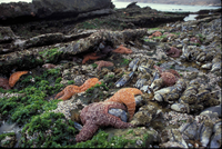
Channel Islands National Park, Code: CHIS
Channel Islands National Park, California
Latitude: 34.0039100646973, Longitude: -119.725196838379
Latitude: 34.0039100646973, Longitude: -119.725196838379
5/19/2009 12:00:00 AM
05/19/2009
Extracted from: Final Cut Server database
Public Can View
Person: Program Manager
Organization: Channel Islands National Park
Address: 1901 Spinnaker Drive, Ventura CA 93001
Organization: Channel Islands National Park
Address: 1901 Spinnaker Drive, Ventura CA 93001
Wednesday, July 1, 2020 8:47:05 AM
Wednesday, July 1, 2020 8:47:05 AM
srjl_area_hal_plot_fa90.jpg
jpg
628.7 kB
Scenic