Select Item below to DOWNLOAD - Once item is selected, right click and choose 'save as'
ab182bbb40e0475e8fdf4d80d1f18754
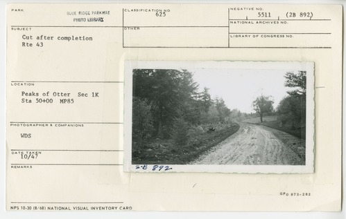
Cut after completion of Route 43 relocation
Cut after completion of Route 43 relocation
Peaks of Otter, Section 1-K, Station 50+00, Milepost 85
U.S. National Park Service
Permission must be secured from the individual copyright owners to reproduce any copyrighted materials contained within this website.
WDS
Public domain
Roadway, (Blue Ridge Parkway Construction Project)
Image
Blue Ridge Parkway, Code: BLRI
Milepost 85, Blue Ridge Parkway
Blue Ridge Parkway
Latitude: 36.4365005493164, Longitude: -81.070556640625
Blue Ridge Parkway
Latitude: 36.4365005493164, Longitude: -81.070556640625
October 1947
10/01/1947 - 10/30/1947
Public Can View
Organization: US National Park Service
Role: Museum Curator
Address: Blue Ridge Parkway Headquarters
Email: blri_info@nps.gov
Role: Museum Curator
Address: Blue Ridge Parkway Headquarters
Email: blri_info@nps.gov
Wednesday, January 22, 2020 9:08:01 AM
Wednesday, January 22, 2020 9:08:01 AM
0054_p_otter_area.tif
tif
11.7 MB
Scenic
,
Historic