Select Item below to DOWNLOAD - Once item is selected, right click and choose 'save as'
f6c521dfbaa440d1896f6ba01e368f4a
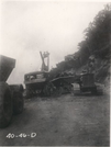
Rough grading equipment in rock cut at Station 51+00
Rough grading equipment in rock cut at Station 51+00
Photographs from the Blue Ridge Parkway Final Construction Report, Project 1-J-1, March 2, 1942
U.S. National Park Service
Permission must be secured from the individual copyright owners to reproduce any copyrighted materials contained within this website.
Unknown
Public domain
Roadway, (Blue Ridge Parkway Construction Project)
Image
Blue Ridge Parkway, Code: BLRI
Section 1-J, 74.8-85.6, Blue Ridge Parkway
Blue Ridge Parkway
Latitude: 36.4365005493164, Longitude: -81.070556640625
Blue Ridge Parkway
Latitude: 36.4365005493164, Longitude: -81.070556640625
circa 1940s
Public Can View
Organization: US National Park Service
Role: Museum Curator
Address: Blue Ridge Parkway Headquarters
Email: blri_info@nps.gov
Role: Museum Curator
Address: Blue Ridge Parkway Headquarters
Email: blri_info@nps.gov
Sunday, March 22, 2020 9:38:38 AM
Sunday, March 22, 2020 9:38:38 AM
BLRI_FinalConstrRpt_1J105.tif
tif
875.9 kB
Scenic
,
Historic