Select Item below to DOWNLOAD - Once item is selected, right click and choose 'save as'
db79be05ae0d41aeae730e285e42ff39
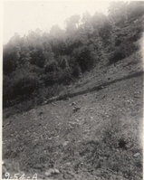
Cleared fill site at Station 196+75 showing 18" pipe installation
Cleared fill site at Station 196+75 showing 18" pipe installation
Photographs from the Blue Ridge Parkway Final Construction Report, Project 1-J-1, March 2, 1942
U.S. National Park Service
Permission must be secured from the individual copyright owners to reproduce any copyrighted materials contained within this website.
Unknown
Public domain
Roadway, (Blue Ridge Parkway Construction Project)
Image
Blue Ridge Parkway, Code: BLRI
Section 1-J, 74.8-85.6, Blue Ridge Parkway
Blue Ridge Parkway
Latitude: 36.4365005493164, Longitude: -81.070556640625
Blue Ridge Parkway
Latitude: 36.4365005493164, Longitude: -81.070556640625
circa 1940s
Public Can View
Organization: US National Park Service
Role: Museum Curator
Address: Blue Ridge Parkway Headquarters
Email: blri_info@nps.gov
Role: Museum Curator
Address: Blue Ridge Parkway Headquarters
Email: blri_info@nps.gov
Sunday, March 22, 2020 9:38:55 AM
Sunday, March 22, 2020 9:38:55 AM
BLRI_FinalConstrRpt_1J101.tif
tif
863.5 kB
Scenic
,
Historic