Select Item below to DOWNLOAD - Once item is selected, right click and choose 'save as'
da4d087cc9434089911b3ac552794aab
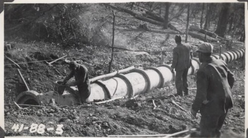
Laying 30' culvert pipe, Station 122+34
Laying 30' culvert pipe, Station 122+34
Photographs from the Blue Ridge Parkway Final Construction Report, Project 1-G-1, August 4, 1943
U.S. National Park Service
Permission must be secured from the individual copyright owners to reproduce any copyrighted materials contained within this website.
Unknown
Public domain
Image
Blue Ridge Parkway, Code: BLRI
Section 1-G, Milepost 50.1-63.7, Blue Ridge Parkway
Blue Ridge Parkway
Latitude: 36.4365005493164, Longitude: -81.070556640625
Blue Ridge Parkway
Latitude: 36.4365005493164, Longitude: -81.070556640625
circa 1940s
Public Can View
Organization: US National Park Service
Role: Museum Curator
Address: Blue Ridge Parkway Headquarters
Email: blri_info@nps.gov
Role: Museum Curator
Address: Blue Ridge Parkway Headquarters
Email: blri_info@nps.gov
Sunday, March 22, 2020 9:51:09 AM
Sunday, March 22, 2020 9:51:09 AM
BLRI_FinalConstrRpt_1G108.tif
tif
718.0 kB
Scenic
,
Historic