Select Item below to DOWNLOAD - Once item is selected, right click and choose 'save as'
b9d6402978844ec485275a93377888e5
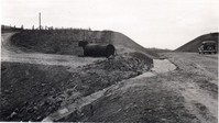
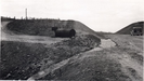
Before grading and seeding at Station 4+75
Before grading and seeding at Station 4+75
Photographs from the Blue Ridge Parkway Final Construction Report, Project 1-P, December 23, 1941
U.S. National Park Service
Permission must be secured from the individual copyright owners to reproduce any copyrighted materials contained within this website.
Unknown
Public domain
Roadway, (Blue Ridge Parkway Construction Project)
Image
Blue Ridge Parkway, Code: BLRI
Section 1-P, Milepost 136.0-144.2, Blue Ridge Parkway
Blue Ridge Parkway
Latitude: 36.4365005493164, Longitude: -81.070556640625
Blue Ridge Parkway
Latitude: 36.4365005493164, Longitude: -81.070556640625
circa 1940s
Public Can View
Organization: US National Park Service
Role: Museum Curator
Address: Blue Ridge Parkway Headquarters
Email: blri_info@nps.gov
Role: Museum Curator
Address: Blue Ridge Parkway Headquarters
Email: blri_info@nps.gov
Saturday, March 21, 2020 10:09:04 AM
Saturday, March 21, 2020 10:09:04 AM
BLRI_FinalConstrRpt_1P19.tif
tif
1.1 MB
Scenic
,
Historic