Select Item below to DOWNLOAD - Once item is selected, right click and choose 'save as'
8da96d291bf545ac9fd1d809eddac8c9
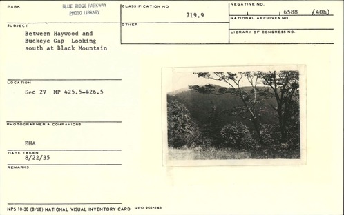
View between Haywood and Buckeye Gap, looking south at Black Mountain
View between Haywood and Buckeye Gap, looking south at Black Mountain
Approximately Milepost 425.5-426.5, Blue Ridge Parkway
U.S. National Park Service
Permission must be secured from the individual copyright owners to reproduce any copyrighted materials contained within this website.
E. H. Abbuehl
Public domain
Image
Blue Ridge Parkway, Code: BLRI
Blue Ridge Parkway
Latitude: 36.4365005493164, Longitude: -81.070556640625
Latitude: 36.4365005493164, Longitude: -81.070556640625
August 22, 1935
08/22/1935
Public Can View
Organization: US National Park Service
Role: Museum Curator
Address: Blue Ridge Parkway Headquarters
Email: blri_info@nps.gov
Role: Museum Curator
Address: Blue Ridge Parkway Headquarters
Email: blri_info@nps.gov
Monday, February 3, 2020 5:20:33 PM
Monday, February 3, 2020 5:20:33 PM
0004_MP425_1.tif
tif
10.9 MB
Scenic
,
Historic