Select Item below to DOWNLOAD - Once item is selected, right click and choose 'save as'
57c5ccf781204bcb95372d2a2ac2140b
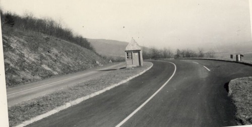
Completed checking Station area, looking northeast
Completed checking Station area, looking northeast
Photographs from the Blue Ridge Parkway Final Construction Report, Project 1-B-4, June 12, 1953
U.S. National Park Service
Permission must be secured from the individual copyright owners to reproduce any copyrighted materials contained within this website.
Unknown
Public domain
Roadway, (Blue Ridge Parkway Construction Project)
Image
Blue Ridge Parkway, Code: BLRI
Section 1-B, Milepost 0-6.1, Blue Ridge Parkway
Blue Ridge Parkway
Latitude: 36.4365005493164, Longitude: -81.070556640625
Blue Ridge Parkway
Latitude: 36.4365005493164, Longitude: -81.070556640625
circa 1950s
Public Can View
Organization: US National Park Service
Role: Museum Curator
Address: Blue Ridge Parkway Headquarters
Email: blri_info@nps.gov
Role: Museum Curator
Address: Blue Ridge Parkway Headquarters
Email: blri_info@nps.gov
Sunday, March 22, 2020 10:12:19 AM
Sunday, March 22, 2020 10:12:19 AM
BLRI_FinalConstrRpt_1-B417.tif
tif
972.3 kB
Scenic
,
Historic