Select Item below to DOWNLOAD - Once item is selected, right click and choose 'save as'
0d761656d8b04cb68cdcb279d3fe7b77
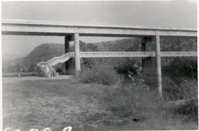
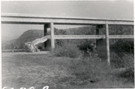
View of southerly approach for James River Foot Bridge
View of southerly approach for James River Foot Bridge
Photographs from the Blue Ridge Parkway Final Construction Report, Project 1H8, February 18, 1966
U.S. National Park Service
Permission must be secured from the individual copyright owners to reproduce any copyrighted materials contained within this website.
Unknown
Public domain
Bridge, (Blue Ridge Parkway Construction Project)
Image
Blue Ridge Parkway, Code: BLRI
Section 1-H, Milepost 63.7-74.8, Blue Ridge Parkway
Blue Ridge Parkway
Latitude: 36.4365005493164, Longitude: -81.070556640625
Blue Ridge Parkway
Latitude: 36.4365005493164, Longitude: -81.070556640625
circa 1960s
Public Can View
Organization: US National Park Service
Role: Museum Curator
Address: Blue Ridge Parkway Headquarters
Email: blri_info@nps.gov
Role: Museum Curator
Address: Blue Ridge Parkway Headquarters
Email: blri_info@nps.gov
Sunday, March 22, 2020 9:39:00 AM
Sunday, March 22, 2020 9:39:00 AM
BLRI_FinalConstrRpt_1H803.tif
tif
784.2 kB
Scenic
,
Historic