Select Item below to DOWNLOAD - Once item is selected, right click and choose 'save as'
fb45584b3f334fd383fc6846ac03472f
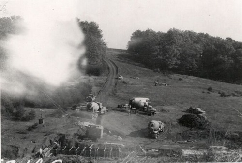
Placing concrete in box culvert at Station 627+45
Placing concrete in box culvert at Station 627+45
Photographs from the Blue Ridge Parkway Final Construction Report, Project 1-M-1, May 11, 1970
U.S. National Park Service
Permission must be secured from the individual copyright owners to reproduce any copyrighted materials contained within this website.
Unknown
Public domain
Image
Blue Ridge Parkway, Code: BLRI
Section 1-M, Milepost 105.8-121.4, Blue Ridge Parkway
Blue Ridge Parkway
Latitude: 36.4365005493164, Longitude: -81.070556640625
Blue Ridge Parkway
Latitude: 36.4365005493164, Longitude: -81.070556640625
circa 1960s
Public Can View
Organization: US National Park Service
Role: Museum Curator
Address: Blue Ridge Parkway Headquarters
Email: blri_info@nps.gov
Role: Museum Curator
Address: Blue Ridge Parkway Headquarters
Email: blri_info@nps.gov
Sunday, March 22, 2020 9:26:03 AM
Sunday, March 22, 2020 9:26:03 AM
BLRI_FinalConstrRpt_1M02.tif
tif
939.6 kB
Scenic
,
Historic