Select Item below to DOWNLOAD - Once item is selected, right click and choose 'save as'
C6218F39-1DD8-B71C-07D72464D8D9356C
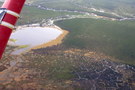
Patterned Ground
Patterned Ground
Polygon patterns on the tundra develop from yearly freeze-thaw cycles. Wedges of ice that extend vertically into the ground develop geometric shapes due to the crystal structure of the ice.
Aerial view of polygon patterns on tundra
U.S. National Park Service
Permission must be secured from the individual copyright owners to reproduce any copyrighted materials contained within this website. Digital assets without any copyright restrictions are public domain.
Public domain:Full Granting Rights
Image
Noatak National Preserve, Code: NOAT
Noatak National Preserve
Latitude: 68.2164459228, Longitude: -162.191162109
Latitude: 68.2164459228, Longitude: -162.191162109
8/31/2012 11:16:14 AM
Public Can View
Tuesday, January 2, 2018 2:59:05 PM
Tuesday, January 2, 2018 2:59:05 PM
C621EAAF-1DD8-B71C-07CBD84E1E9177B5.jpg
Canon Canon, Canon PowerShot G12
1/100 sec at f / 3.2
8.108 mm
ISO 125
Friday, August 31, 2012 5:16:14 PM
jpg
1.1 MB
Scenic