Select Item below to DOWNLOAD - Once item is selected, right click and choose 'save as'
bc44f5cf-4da0-4bbd-96cf-1811f20d7490
Notching the Dam—Day 8 Top Revealed
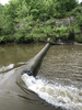
As the water level falls by Day 8, the top of the concrete Brecksville Diversion Dam becomes visible. Water flows through the notch in the foreground. The west dam abutment and Cuyahoga Valley Scenic Railroad tracks are in the background.
As the water level falls by Day 8, the top of the concrete Brecksville Diversion Dam becomes visible. Water flows through the notch in the foreground. The west dam abutment and Cuyahoga Valley Scenic Railroad tracks are in the background.
Permission must be secured from the individual copyright owners to reproduce any copyrighted materials contained within this website. Digital assets without any copyright restrictions are public domain.
Friends of the Crooked River / Dianne Sumego
Public domain:Full Granting Rights
Image
Cuyahoga Valley National Park, Code: CUVA
Cuyahoga Valley National Park, Ohio
Latitude: 41.1502799987793, Longitude: -81.5678787231445
Latitude: 41.1502799987793, Longitude: -81.5678787231445
05/28/2020
05/28/2020
Public Can View
Friday, July 31, 2020 12:21:57 PM
Friday, July 31, 2020 12:21:57 PM
20200528 CRWT-SRBT notching dam FOCR Dianne Sumego.jpg
Apple Apple, iPhone 8 Plus 20, iPhone 8 Plus back dual camera 3.99mm f/1.8
1/232 sec at f / 1.8
3.99 mm
ISO 20
Thursday, May 28, 2020 4:42:46 PM
jpg
5.0 MB
Scenic