Select Item below to DOWNLOAD - Once item is selected, right click and choose 'save as'
953abdce-e359-4ec7-8bcd-376c812a0583
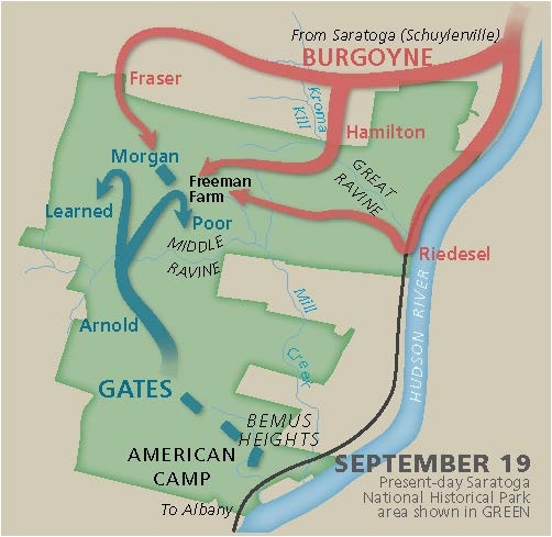
September 19, 1777 Battle Map - Saratoga National Historical Park
Map of the Battle of Saratoga fought on September 19, 1777 between Burgoyne’s troops, represented by red lines in the north of Saratoga National Historical Park, and blue lines representing Gates’s troops to the south.
Screen-viewable file; Adobe print production files can be downloaded from the Compressed zip Version link
Map Projection: Other; Map Type: unassigned
U.S. National Park Service
The National Park Service maps are government produced and are in the public domain. Anyone may, without restriction under U.S. copyright laws: Reproduce the work in print or digital form; Create derivative works; Perform the work publicly; Display the work; Distribute copies or digitally transfer the work to the public by sale or other transfer of ownership, or by rental, lease, or lending. Please note, a user who modifies and/or republishes National Park Service maps are responsible for any problems encountered with the maps, due to their change or modification.
Public domain
Document
Saratoga National Historical Park, Code: SARA
Saratoga National Historical Park, Saratoga County, New York
Latitude: 42.9943008422852, Longitude: -73.6440963745117
Latitude: 42.9943008422852, Longitude: -73.6440963745117
2022/06/01
Public Can View
Person: Harpers Ferry Center
Organization: US National Park Service
Address: Harpers Ferry Center, Harpers Ferry, WV
Email: HFC_Cartography@nps.gov
Organization: US National Park Service
Address: Harpers Ferry Center, Harpers Ferry, WV
Email: HFC_Cartography@nps.gov
Monday, May 2, 2022 10:16:46 PM
Friday, September 26, 2025 11:37:35 PM
SARAmap3.pdf
pdf
66.6 kB
Map