Select Item below to DOWNLOAD - Once item is selected, right click and choose 'save as'
6a19c8a8-34bf-4ba0-96f3-1977cc5d3520
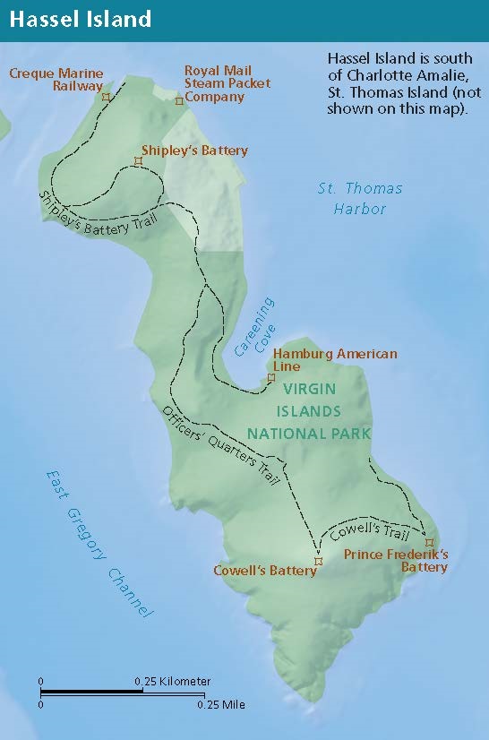
Hassel Island Map - Virgin Islands National Park
Map of Hassel Island, part of Virgin Islands National Park. The tall, roughly oval island is shaded green. Trails are represented with black dashed lines, and St. Thomas Harbor to the northeast and East Gregory Channel to the southwest are shown in blue.
Screen-viewable file; Adobe print production files can be downloaded from the Compressed zip Version link
Map Projection: Wm; Map Type: detail map
U.S. National Park Service
The National Park Service maps are government produced and are in the public domain. Anyone may, without restriction under U.S. copyright laws: Reproduce the work in print or digital form; Create derivative works; Perform the work publicly; Display the work; Distribute copies or digitally transfer the work to the public by sale or other transfer of ownership, or by rental, lease, or lending. Please note, a user who modifies and/or republishes National Park Service maps are responsible for any problems encountered with the maps, due to their change or modification.
Public domain
Document
Virgin Islands National Park, Code: VIIS
Virgin Islands National Park, Virgin Islands
Latitude: 18.3439407348633, Longitude: -64.739860534668
Latitude: 18.3439407348633, Longitude: -64.739860534668
2022/07/01
07/01/2022
Public Can View
Person: Harpers Ferry Center
Organization: US National Park Service
Address: Harpers Ferry Center, Harpers Ferry, WV
Email: HFC_Cartography@nps.gov
Organization: US National Park Service
Address: Harpers Ferry Center, Harpers Ferry, WV
Email: HFC_Cartography@nps.gov
Wednesday, March 22, 2023 9:22:08 PM
Friday, September 26, 2025 11:38:05 PM
VIISmap6.pdf
pdf
810.6 kB
Map