Select Item below to DOWNLOAD - Once item is selected, right click and choose 'save as'
2fd40885ef634def89e4159211ed0d89
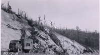
Rock slope showing source of masonry stone at Station 54
Rock slope showing source of masonry stone at Station 54
Photographs from the Blue Ridge Parkway Final Construction Report, Project 1L3-L4, May 19, 1953
U.S. National Park Service
Permission must be secured from the individual copyright owners to reproduce any copyrighted materials contained within this website.
Unknown
Public domain
Image
Blue Ridge Parkway, Code: BLRI
Section 1-L, Milepost 97.6-105.8, Blue Ridge Parkway
Blue Ridge Parkway
Latitude: 36.4365005493164, Longitude: -81.070556640625
Blue Ridge Parkway
Latitude: 36.4365005493164, Longitude: -81.070556640625
circa 1950s
Public Can View
Organization: US National Park Service
Role: Museum Curator
Address: Blue Ridge Parkway Headquarters
Email: blri_info@nps.gov
Role: Museum Curator
Address: Blue Ridge Parkway Headquarters
Email: blri_info@nps.gov
Sunday, March 22, 2020 9:26:12 AM
Sunday, March 22, 2020 9:26:12 AM
BLRI_FinalConstrRpt_1L3L424.tif
tif
680.4 kB
Scenic
,
Historic