Select Item below to DOWNLOAD - Once item is selected, right click and choose 'save as'
2d17c9b1dc6b443c959212b59d139150
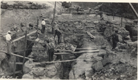
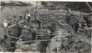
Abutment and wing construction
Abutment and wing construction
Photographs from the Blue Ridge Parkway Final Construction Report, Project 1-K-3, December 22, 1942
U.S. National Park Service
Permission must be secured from the individual copyright owners to reproduce any copyrighted materials contained within this website.
Unknown
Public domain
Image
Blue Ridge Parkway, Code: BLRI
VA Route 43 near Bearwallow Gap, Milepost 90.9, Blue Ridge Parkway
Blue Ridge Parkway
Latitude: 36.4365005493164, Longitude: -81.070556640625
Blue Ridge Parkway
Latitude: 36.4365005493164, Longitude: -81.070556640625
circa 1940s
Public Can View
Organization: US National Park Service
Role: Museum Curator
Address: Blue Ridge Parkway Headquarters
Email: blri_info@nps.gov
Role: Museum Curator
Address: Blue Ridge Parkway Headquarters
Email: blri_info@nps.gov
Sunday, March 22, 2020 9:33:06 AM
Sunday, March 22, 2020 9:33:06 AM
BLRI_FinalConstrRpt_1K302.tif
tif
1.2 MB
Scenic
,
Historic