Select Item below to DOWNLOAD - Once item is selected, right click and choose 'save as'
1793ec6d2f384ed0a4e070fb485ece29
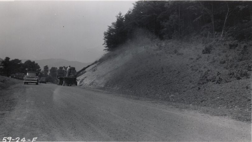
Mulching at Station 302, also showing rough graded roadway with base stone in place
Mulching at Station 302, also showing rough graded roadway with base stone in place
Photographs from the Blue Ridge Parkway Final Construction Report, Project 1N1, February 8, 1962
U.S. National Park Service
Permission must be secured from the individual copyright owners to reproduce any copyrighted materials contained within this website.
Unknown
Public domain
Roadway, (Blue Ridge Parkway Construction Project)
Image
Blue Ridge Parkway, Code: BLRI
Section 1-N, Milepost 121.4-136.0, Blue Ridge Parkway
Blue Ridge Parkway
Latitude: 36.4365005493164, Longitude: -81.070556640625
Blue Ridge Parkway
Latitude: 36.4365005493164, Longitude: -81.070556640625
circa 1960s
Public Can View
Organization: US National Park Service
Role: Museum Curator
Address: Blue Ridge Parkway Headquarters
Email: blri_info@nps.gov
Role: Museum Curator
Address: Blue Ridge Parkway Headquarters
Email: blri_info@nps.gov
Saturday, March 21, 2020 10:10:49 AM
Saturday, March 21, 2020 10:10:49 AM
BLRI_FinalConstrRpt_1N108.tif
tif
1.1 MB
Scenic
,
Historic