Select Item below to DOWNLOAD - Once item is selected, right click and choose 'save as'
f7e006ba-c37e-4410-8819-8d6c833e0810
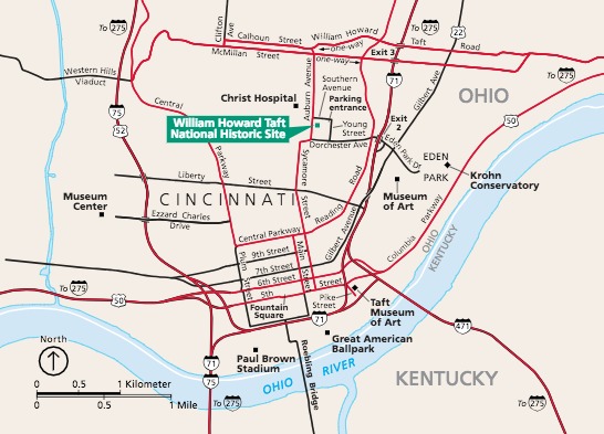
Park Map - William Howard Taft National Historic Site
Map of William Howard Taft National Historic Site in Ohio. The site is in the upper middle, in Cincinnati, among beige land and red and black streets. The blue Ohio River, and Ohio-Kentucky state line, undulates across the lower third of the map.
Screen-viewable file; Adobe print production files can be downloaded from the Compressed zip Version link
Map Projection: WM; Map Type: park map
U.S. National Park Service
The National Park Service maps are government produced and are in the public domain. Anyone may, without restriction under U.S. copyright laws: Reproduce the work in print or digital form; Create derivative works; Perform the work publicly; Display the work; Distribute copies or digitally transfer the work to the public by sale or other transfer of ownership, or by rental, lease, or lending. Please note, a user who modifies and/or republishes National Park Service maps are responsible for any problems encountered with the maps, due to their change or modification.
Public domain
Document
William Howard Taft National Historic Site, Code: WIHO
William Howard Taft National Historic Site, Hamilton County, Ohio
Latitude: 39.119701385498, Longitude: -84.5075988769531
Latitude: 39.119701385498, Longitude: -84.5075988769531
2018-06-22
Public Can View
Person: Harpers Ferry Center
Organization: US National Park Service
Address: Harpers Ferry Center, Harpers Ferry, WV
Email: HFC_Cartography@nps.gov
Organization: US National Park Service
Address: Harpers Ferry Center, Harpers Ferry, WV
Email: HFC_Cartography@nps.gov
Monday, May 2, 2022 11:01:39 PM
Friday, September 26, 2025 11:38:16 PM
WIHOmap1.pdf
pdf
692.2 kB
Map