Select Item below to DOWNLOAD - Once item is selected, right click and choose 'save as'
ee719e42-fad1-4a45-ae2b-abcf50c2cc96
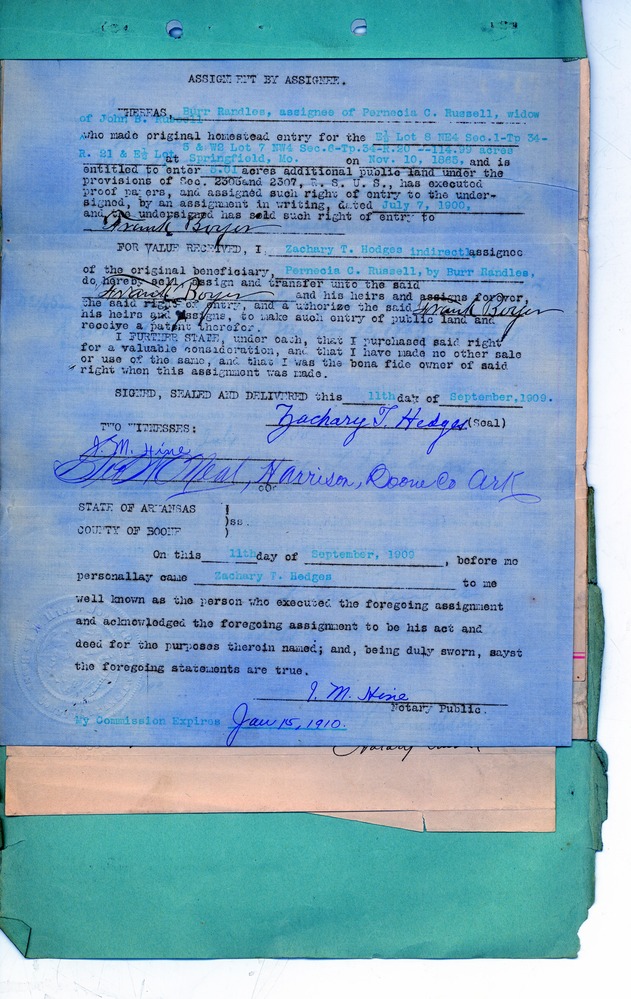
Assignment by Assignee, Zachary Hedges to Frank Boyer, 1909
Scanned image of a land assignment form. See description for text.
ASSIGNMENT BY ASSIGNEE.
WHEREAS Burr Randles, assignee of Pernecia C. Russell, widow of John B. Russell who made original homestead entry for the E ½ Lot 8 NE4 Sec.1-To 34-R. 21 & E ½ Lot 5 & W2 Lot 7 NW4 Sec.6-Tp.34-R.20—114.99 acres at Springfield, No. on Nov. 10, 1865, and is entitled to enter 5.01 acres additional public land under the provisions of Sec. 2306 and 2307, R. S. U. S., has executed proof papers, and assigned such right of entry to the undersigned, by an assignment in writing, dated July 7, 1900, and the undersigned has sold such right of entry to [signature] Frank Boyer
FOR VALUE RECEIVED, I, Zachary T. Hedges indirectly assignee of the original beneficiary, Pernecia C. Russell, by Burr Randles, do hereby sell, assign and transfer unto the said [signature] Frank Boyer and his heirs and assigns forever, the said right of entry, and authorize the said [signature] Frank Boyer his heirs and assigns, to make such entry of public land and receive a patent therefor.
I FURTHER STATE, under oath, that I purchased said right for a valuable consideration, and that I have made no other sale or use of the same , and that I was the bona fide owner of said right when this assignment was made.
SIGNED, SEALED AND DELIVERED this 11th day of September, 1909.
[signature] Zachary T. Hedges (Seal)
TWO WITNESSES:
[signature] I. M. Hine
[signature] Bun[?] O’Neal, Harrison, Boone Co Ark
STATE OF ARKANSAS
COUNTY OF BOONE ss
On this 11th day of September, 1909, before me personally came Zachary T. Hedges to me well known as the person who executed the foregoing assignment and acknowledged the foregoing assignment to be his act and deed for the purposes therein named; and, being duly sworn, sayst the foregoing statements are true.
[signature] I. M. Hine
Notary Public
My Commission Expires Jan 15, 1910.
Federal records are public domain
National Archives and Records Administration
Public domain:Full Granting Rights
Document
Homestead National Historical Park, Code: HOME
Homestead National Historical Park, Gage County, Nebraska
Latitude: 40.2879981994629, Longitude: -96.8339004516602
Latitude: 40.2879981994629, Longitude: -96.8339004516602
unknown
01/01/0001
Land Entry Case Files: Homestead Final Certificates. Record Group 49: Records of the Bureau of Land Management. National Archives and Records Administration.
Public Can View
Organization: Homestead National Historical Park
Address: 8523 W State Hwy 4, Beatrice, NE 68310
Email: home_information@nps.gov
Address: 8523 W State Hwy 4, Beatrice, NE 68310
Email: home_information@nps.gov
Tuesday, April 13, 2021 10:05:40 AM
Tuesday, April 13, 2021 10:05:40 AM
RG49.B14102.F420914.16.tif
Monday, January 1, 0001 12:00:00 AM
tif
48.0 MB
Scenic
,
Historic