Select Item below to DOWNLOAD - Once item is selected, right click and choose 'save as'
e0ab52eb36e74ab698e14ca6e5e2220f
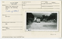
Sharp Top pedestrian shelter and parking area
Sharp Top pedestrian shelter and parking area
Peaks of Otter, Milepost 85.9, Blue Ridge Parkway
U.S. National Park Service
Permission must be secured from the individual copyright owners to reproduce any copyrighted materials contained within this website.
Warren D. Lewis
Public domain
Image
Blue Ridge Parkway, Code: BLRI
Milepost 85, Blue Ridge Parkway
Blue Ridge Parkway
Latitude: 36.4365005493164, Longitude: -81.070556640625
Blue Ridge Parkway
Latitude: 36.4365005493164, Longitude: -81.070556640625
July 8, 1949
07/08/1949
Public Can View
Organization: US National Park Service
Role: Museum Curator
Address: Blue Ridge Parkway Headquarters
Email: blri_info@nps.gov
Role: Museum Curator
Address: Blue Ridge Parkway Headquarters
Email: blri_info@nps.gov
Wednesday, January 8, 2020 3:24:29 PM
Wednesday, January 8, 2020 3:24:29 PM
0021_p_otter_area.tif
tif
11.7 MB
Scenic
,
Historic