Select Item below to DOWNLOAD - Once item is selected, right click and choose 'save as'
C566810C-1DD8-B71C-078DB1B2695FB88D
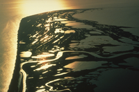
Cape Krusenstern Beach Ridges
Aerial view of beach ridges and wetlands
5000 years of accumulated beach ridges show up well as concentric curved lines in the light of the summer sun. The Arctic Ocean is on the left and Krusenstern Lagoon is on the right. Low angle sunlight makes the wetlands and ridges glow.
U.S. National Park Service
Permission must be secured from the individual copyright owners to reproduce any copyrighted materials contained within this website. Digital assets without any copyright restrictions are public domain.
NPS Photo
Public domain:Full Granting Rights
Image
Cape Krusenstern National Monument, Code: CAKR
Cape Krusenstern National Monument, Northwest Arctic Borough, Alaska
Latitude: 67.4122009277344, Longitude: -163.503005981445
Latitude: 67.4122009277344, Longitude: -163.503005981445
1/30/2013 11:10:09 AM
Public Can View
Thursday, May 3, 2018 8:48:16 AM
Thursday, May 3, 2018 8:48:16 AM
C567A21F-1DD8-B71C-07DC9E9878FBFE33.jpg
Wednesday, January 30, 2013 6:10:09 PM
jpg
1.7 MB
Scenic