Select Item below to DOWNLOAD - Once item is selected, right click and choose 'save as'
9c9935c2-52ad-43a8-a0b7-d4c398ea6d37
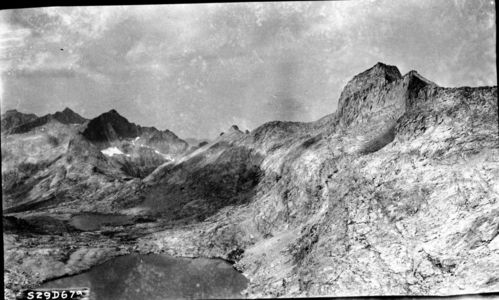
High Sierra Trail Investigation, Kaweah Gap, west slope of Nine Lakes Basin showing route from Kaweah Gap toward Triple Divide Pass. Advantage of rock benches to relieve rock excavation may produce a
SEKI Historic Image
High Sierra Trail Investigation, Kaweah Gap, west slope of Nine Lakes Basin showing route from Kaweah Gap toward Triple Divide Pass. Advantage of rock benches to relieve rock excavation may produce a rolling grade, maximum of 15%. Mt. Stewart on right. Far Left panel of a four panel panorama.
John Diehl, 290700, Nine Rivers Basin, SNP, High Sierra Trail Investigation, Kaweah Gap, west slope of Nine Lakes Basin showing route from Kaweah Gap toward Triple Divide Pass. Advantage of rock benches to relieve rock excavation may produce a rolling grade, maximum of 15%. Mt. Stewart on right. Far Left panel of a four panel panorama.
Permission must be secured from the individual copyright owners to reproduce any copyrighted materials contained within this website. Digital assets without any copyright restrictions are public domain.
Public domain
Image
Nine Rivers Basin, Tulare County, California
07/01/1929
option 1
Public Can View
Wednesday, January 11, 2017 9:56:23 AM
Wednesday, January 11, 2017 9:56:23 AM
01210.tif
Monday, January 1, 0001 12:00:00 AM
tif
13.4 MB
Inventory