Select Item below to DOWNLOAD - Once item is selected, right click and choose 'save as'
83934285-f2d0-45ed-8d87-c9f35bad00e6
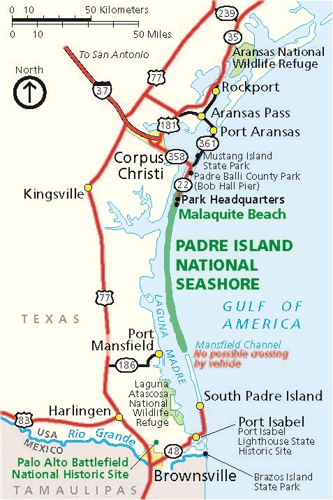
Area Map - Padre Island National Seashore
Area map of Padre Island National Seashore in Texas. The park, shown in green, curves like a parenthesis along the coastline of Texas in the Gulf of America. Mainland Texas is shown in beige, Mexico in pale gray, and roads in red.
Screen-viewable file; Adobe print production files can be downloaded from the Compressed zip Version link
Map Projection: Other; Map Type: unassigned
U.S. National Park Service
The National Park Service maps are government produced and are in the public domain. Anyone may, without restriction under U.S. copyright laws: Reproduce the work in print or digital form; Create derivative works; Perform the work publicly; Display the work; Distribute copies or digitally transfer the work to the public by sale or other transfer of ownership, or by rental, lease, or lending. Please note, a user who modifies and/or republishes National Park Service maps are responsible for any problems encountered with the maps, due to their change or modification.
Public domain
Document
Padre Island National Seashore, Code: PAIS
Padre Island National Seashore, Texas
Latitude: 26.7036590576172, Longitude: -97.3406829833984
Latitude: 26.7036590576172, Longitude: -97.3406829833984
2025/02/11
Public Can View
Person: Harpers Ferry Center
Organization: US National Park Service
Address: Harpers Ferry Center, Harpers Ferry, WV
Email: HFC_Cartography@nps.gov
Organization: US National Park Service
Address: Harpers Ferry Center, Harpers Ferry, WV
Email: HFC_Cartography@nps.gov
Wednesday, February 12, 2025 2:14:14 PM
Friday, September 26, 2025 11:37:01 PM
PAISmap2.pdf
pdf
246.3 kB
Map