Select Item below to DOWNLOAD - Once item is selected, right click and choose 'save as'
7e8bd837ed2b4031a8962b8507a5cb76
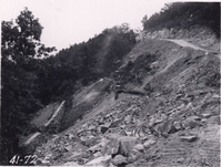
Laying fill behind wall at Station 620
Laying fill behind wall at Station 620
Photographs from the Blue Ridge Parkway Final Construction Report, Project 1-K-2, June 29, 1942
U.S. National Park Service
Permission must be secured from the individual copyright owners to reproduce any copyrighted materials contained within this website.
Unknown
Public domain
Roadway, (Blue Ridge Parkway Construction Project)
Image
Blue Ridge Parkway, Code: BLRI
Section 1-K, Milepost 85.6-97.6, Blue Ridge Parkway
Blue Ridge Parkway
Latitude: 36.4365005493164, Longitude: -81.070556640625
Blue Ridge Parkway
Latitude: 36.4365005493164, Longitude: -81.070556640625
circa 1940s
Public Can View
Organization: US National Park Service
Role: Museum Curator
Address: Blue Ridge Parkway Headquarters
Email: blri_info@nps.gov
Role: Museum Curator
Address: Blue Ridge Parkway Headquarters
Email: blri_info@nps.gov
Sunday, March 22, 2020 9:34:08 AM
Sunday, March 22, 2020 9:34:08 AM
BLRI_FinalConstrRpt_1K2003.tif
tif
854.9 kB
Scenic
,
Historic