Select Item below to DOWNLOAD - Once item is selected, right click and choose 'save as'
7dec9ff1-1b39-48c9-ad00-8d610422a126
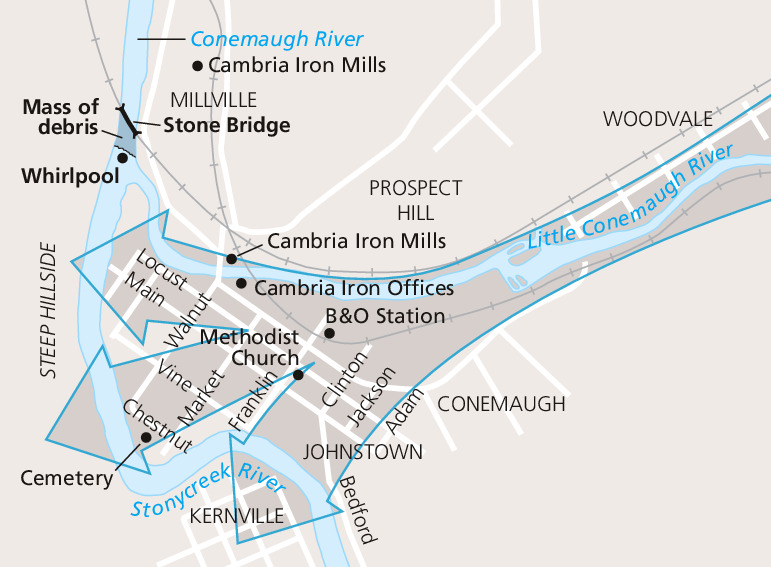
Town Map - Johnstown Flood National Memorial
Map showing the movement of the Johnstown Flood of 1889 as part of the Johnstown Flood National Memorial in Pennsylvania. Oversized gray arrows sweep along the Little Conemaugh River and spread near the lower left corner. Surrounding areas are paler gray, and roads are shown as white lines.
Screen-viewable file; Adobe print production files can be downloaded from the Compressed zip Version link
Map Projection: Other; Map Type: unassigned
U.S. National Park Service
The National Park Service maps are government produced and are in the public domain. Anyone may, without restriction under U.S. copyright laws: Reproduce the work in print or digital form; Create derivative works; Perform the work publicly; Display the work; Distribute copies or digitally transfer the work to the public by sale or other transfer of ownership, or by rental, lease, or lending. Please note, a user who modifies and/or republishes National Park Service maps are responsible for any problems encountered with the maps, due to their change or modification.
Public domain
Document
Johnstown Flood National Memorial, Code: JOFL
Johnstown Flood National Memorial, Cambria County, Pennsylvania
Latitude: 40.3461990356445, Longitude: -78.774299621582
Latitude: 40.3461990356445, Longitude: -78.774299621582
2015-04-28
Public Can View
Person: Harpers Ferry Center
Organization: US National Park Service
Address: Harpers Ferry Center, Harpers Ferry, WV
Email: HFC_Cartography@nps.gov
Organization: US National Park Service
Address: Harpers Ferry Center, Harpers Ferry, WV
Email: HFC_Cartography@nps.gov
Tuesday, April 26, 2022 9:43:06 PM
Friday, September 26, 2025 11:36:02 PM
JOFLmap2.pdf
pdf
78.2 kB
Map