Select Item below to DOWNLOAD - Once item is selected, right click and choose 'save as'
7c3a59de41ba4229aef8a3735277e9e8
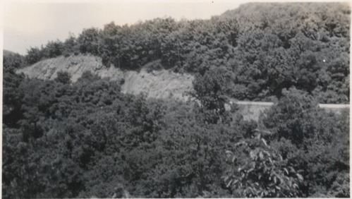
Cut slopes before start of work at Station 334+50
Cut slopes before start of work at Station 334+50
Photographs from the Blue Ridge Parkway Final Construction Report, Project 1H5-J3 -K8, December 9, 1953
U.S. National Park Service
Permission must be secured from the individual copyright owners to reproduce any copyrighted materials contained within this website.
Unknown
Public domain
Roadway, (Blue Ridge Parkway Construction Project)
Image
Blue Ridge Parkway, Code: BLRI
Blue Ridge Parkway
Latitude: 36.4365005493164, Longitude: -81.070556640625
Latitude: 36.4365005493164, Longitude: -81.070556640625
circa 1940s
Public Can View
Organization: US National Park Service
Role: Museum Curator
Address: Blue Ridge Parkway Headquarters
Email: blri_info@nps.gov
Role: Museum Curator
Address: Blue Ridge Parkway Headquarters
Email: blri_info@nps.gov
Sunday, March 22, 2020 9:40:39 AM
Sunday, March 22, 2020 9:40:39 AM
BLRI_FinalConstrRpt_1H5J3K803.tif
tif
711.4 kB
Scenic
,
Historic