Select Item below to DOWNLOAD - Once item is selected, right click and choose 'save as'
154a10c3-83e2-4a89-b843-31ffa81aba1d
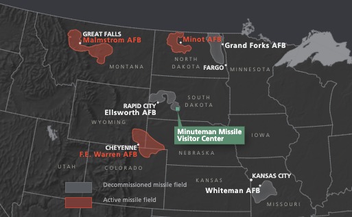
Regional Missile Field Map - Minuteman Missile National Historic Site
Regional missile field map showing sites in relation to Minuteman Missile National Historic Site in South Dakota. The north central United States are outlined in gray against almost black terrain. Missile fields are shown in gray or red.
Screen-viewable file; Adobe print production files can be downloaded from the Compressed zip Version link
Map Projection: Albers; Map Type: battle
U.S. National Park Service
The National Park Service maps are government produced and are in the public domain. Anyone may, without restriction under U.S. copyright laws: Reproduce the work in print or digital form; Create derivative works; Perform the work publicly; Display the work; Distribute copies or digitally transfer the work to the public by sale or other transfer of ownership, or by rental, lease, or lending. Please note, a user who modifies and/or republishes National Park Service maps are responsible for any problems encountered with the maps, due to their change or modification.
Public domain
Document
Minuteman Missile National Historic Site, Code: MIMI
Minuteman Missile National Historic Site, South Dakota
Latitude: 43.8776206970215, Longitude: -101.961402893066
Latitude: 43.8776206970215, Longitude: -101.961402893066
2020-04-08
Public Can View
Person: Harpers Ferry Center
Organization: US National Park Service
Address: Harpers Ferry Center, Harpers Ferry, WV
Email: HFC_Cartography@nps.gov
Organization: US National Park Service
Address: Harpers Ferry Center, Harpers Ferry, WV
Email: HFC_Cartography@nps.gov
Wednesday, April 27, 2022 8:21:46 PM
Friday, September 26, 2025 11:36:34 PM
MIMImap4.pdf
pdf
5.5 MB
Map