Select Item below to DOWNLOAD - Once item is selected, right click and choose 'save as'
ff073fc1-d7d7-439d-ae7d-37969c30f7cd
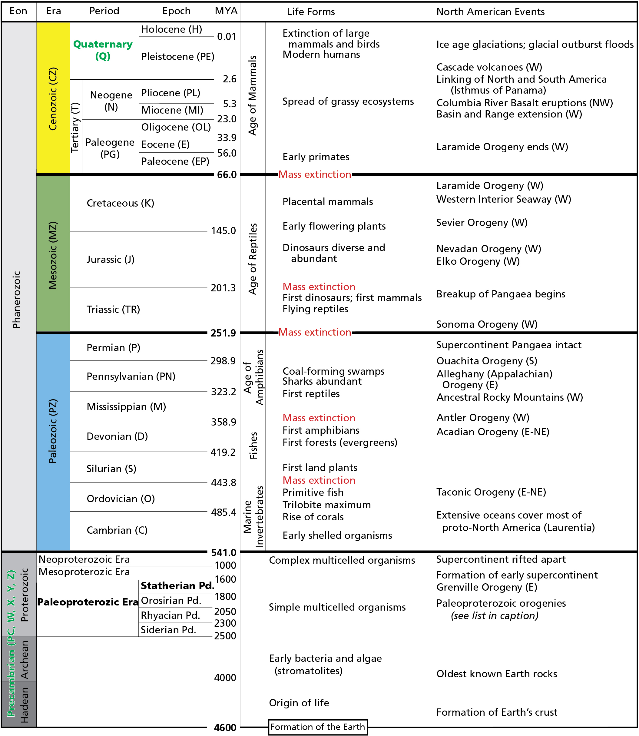
Geologic Time Scale
Geologic time scale. Strata mapped on the surface of the historic site are from the Quaternary Period which encompasses the past 2.56 million years, Sioux Quartzite and Catlinite are from the Statherian Period of the Paleoproterozoic Era. The Statherian Period spans 1,830 to 1,630 million years ago.
Geologic time scale. The divisions of the geologic time scale are organized stratigraphically, with the oldest
divisions at the bottom and the youngest at the top. Time periods representing strata mapped in the Pipestone
National Monument area are in green and at opposite ends of the time scale. GRI map abbreviations for each time
division are in parentheses. Compass directions in parentheses indicate the regional locations of events. Boundary ages
are millions of years ago (MYA). Pd. = “Period.” Paleoproterozoic orogenies include Mazatzal (1,650 million–1,600
million years ago), Yavapai (1,710 million–1,680 million years ago), Trans-Hudson (2,000 million–1,800 million years
ago), and Algoman (1,700 million–2,500 million years ago). 1,000 million years equals 1 billion years.
Permission must be secured from the individual copyright owners to reproduce any copyrighted materials contained within this website. Digital assets without any copyright restrictions are public domain.
National Park
Service graphic using dates from the International Commission on Stratigraphy
Public domain:Full Granting Rights
Image
Pipestone National Monument, Code: PIPE
Pipestone National Monument, Pipestone County, Minnesota
Latitude: 44.013500213623, Longitude: -96.3247985839844
Latitude: 44.013500213623, Longitude: -96.3247985839844
01/01/0001
Public Can View
Friday, August 6, 2021 4:42:50 PM
Friday, August 6, 2021 5:03:50 PM
PIPE_Time_Scale_FY17-01.jpg
Monday, January 1, 0001 12:00:00 AM
jpg
1.1 MB
Scenic