Select Item below to DOWNLOAD - Once item is selected, right click and choose 'save as'
fef7ab47-3c1a-444b-b155-9bdeccee3af2
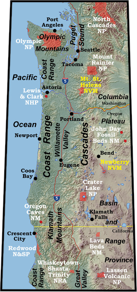
Topography of the Cascadia Subduction Zone
topographic map of the pacific northwest
The Cascadia Subduction Zone has two parallel mountain ranges separated by a low region near sea level.
Permission must be secured from the individual copyright owners to reproduce any copyrighted materials contained within this website. Digital assets without any copyright restrictions are public domain.
Modified from “Oregon's Island in the Sky: Geology Road Guide to Marys Peak, by Robert J. Lillie, Wells Creek Publishers, 75 pp., 2017, www.amazon.com/dp/1540611965.
Public domain:Full Granting Rights
Image
Geologic Resources Division, Code: GRD
01/21/2020
01/21/2020
Public Can View
Friday, January 31, 2020 5:20:23 PM
Friday, January 31, 2020 5:20:23 PM
fig 4-4 cascadia topo new@10x.jpg
Tuesday, January 21, 2020 6:11:08 PM
jpg
5.6 MB
Scenic