Select Item below to DOWNLOAD - Once item is selected, right click and choose 'save as'
fd9b27fe-03e5-40b7-8ac0-13aa54d6504e
Cape Lookout National Seashore, North Carolina
The seashore is a 56 mile long section of the Outer Banks of North Carolina running from Ocracoke Inlet on the northeast to Beaufort Inlet on the southeast. The three undeveloped barrier islands which make up the seashore - North Core Banks, South Core Banks and Shackleford Banks - may seem barren and isolated but they offer many natural and historical features.
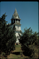
Portsmouth Village Methodist Church steeple.
National Park Service
Permission must be secured from the individual copyright owners to reproduce any copyrighted materials contained within this website. Digital assets without any copyright restrictions are public domain.
Public domain
Image
Cape Lookout National Seashore, Code: CALO
Cape Lookout National Seashore, Carteret County, North Carolina
Latitude: 34.9581985473633, Longitude: -76.1900024414063
Latitude: 34.9581985473633, Longitude: -76.1900024414063
Legacy NPS Focus Record ID : 231486
Title: NPS Office of Communications and Public Affairs Photo Library
URL: http://www.nps.gov/pub_aff/imagebase.html
URL: http://www.nps.gov/pub_aff/imagebase.html
01/05/2004
01/01/1980 - 12/30/1999
Digital image (TIF ; 18.0 MB; 2048 x 3072 ; 300 dpi; 24 bit color). Encoded as MrSID format
Public Can View
Wednesday, September 29, 2004 6:26:08 PM
Thursday, August 10, 2017 2:56:44 PM
calo_portsmouthvillagemethodistchurch_4845.jpg
Monday, January 1, 0001 12:00:00 AM
jpg
645.0 kB
Scenic