Select Item below to DOWNLOAD - Once item is selected, right click and choose 'save as'
fb3fe33c-8e9a-4a27-86c9-b41c85699918
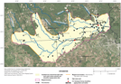
Flood-Inundation Map of Pine Island Bayou for the August and September 2017 Hurricane
Harvey-Related Flood Event in Southeastern Texas and Southwestern Louisiana.
Flood-inundation map of Pine Island Bayou for the August and September 2017 Hurricane Harvey-related flood event in southeastern Texas and southwestern Louisiana.
Pine Island Bayou is a tributary to the Neches River. The Little Pine Island-Pine Island Bayou Corridor Unit of Big Thicket National Preserve is primarily along the Little Pine Island Bayou between Black Creek and Jackson Creek. Much of the preserve area is west of the mapped area boundary. US Geological Survey
streamflow gage 08041749 is located along Pine Island Bayou above BI Pump Plant in Beaumont. It was inundated during the storm event, and a high water mark peak of 8.83 m (28.97 ft) above stream gage datum (water-surface elevation of 8.574 [28.13 ft] above NAVD 88) was documented on October 18, 2017. The date of the peak was not recorded because the station was damaged during the storm event, but the estimated date of the peak is August 30, 2017
Permission must be secured from the individual copyright owners to reproduce any copyrighted materials contained within this website. Digital assets without any copyright restrictions are public domain.
Information from Watson et al. (2018). See current conditions and access historical data for the gage here: https://waterdata.usgs.gov/tx/nwis/uv?site_
no=08041749. Map is figure 8 from Watson et al. (2018).
Public domain:Full Granting Rights
Image
Big Thicket National Preserve, Code: BITH
Big Thicket National Preserve, Texas
Latitude: 30.1642608642578, Longitude: -94.3181228637695
Latitude: 30.1642608642578, Longitude: -94.3181228637695
08/28/2018
08/28/2018
Public Can View
Tuesday, July 20, 2021 4:51:31 PM
Tuesday, July 20, 2021 5:51:46 PM
20_BITH_Pine_Island_Bayou_Hurricane_Harvey_Streamflow_Impacts_USGS_sir20185070 32 cropped.jpg
Tuesday, August 28, 2018 4:17:28 PM
jpg
2.9 MB
Scenic