Select Item below to DOWNLOAD - Once item is selected, right click and choose 'save as'
f9bd7bc9-ad43-495a-a29e-7ce767f699a5
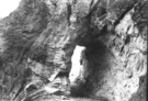
Tunnel on Sugarloaf Trail
Tunnel through rock.
Another view of the tunnel blasted into rhyolite rock. The tunnel is about 6 feet wide, 15 feet long, and about nine feet tall, so horses could go through. Sugarloaf Trail is no longer a trail that horses may use.
Permission must be secured from the individual copyright owners to reproduce any copyrighted materials contained within this website. Digital assets without any copyright restrictions are public domain.
NPS
Public domain:Full Granting Rights
Image
Chiricahua National Monument, Code: CHIR
Chiricahua National Monument, Cochise County, Arizona
Latitude: 32.0121994018555, Longitude: -109.341003417969
Latitude: 32.0121994018555, Longitude: -109.341003417969
01/01/2001
Public Can View
Sunday, October 21, 2018 3:30:30 PM
Sunday, October 21, 2018 3:30:30 PM
132.tif
Monday, January 1, 0001 12:00:00 AM
tif
373.6 kB
Scenic