Select Item below to DOWNLOAD - Once item is selected, right click and choose 'save as'
F7F867A0-04C1-E307-6B85E3982D0514F3
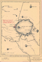
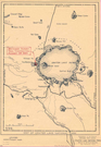
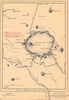
Historic map of the Watchman Trail
A sand-colored map indicates the location of the Watchman Summit Trail construction project and surrounding features.
The Watchman. This historic map shows that trail construction at Watchman Peak is complete, 1932. Meticulous care was given to ensuring the trail's naturalistic appearance, constructed to insure safety and blend with the natural topography of the rim.
U.S. National Park Service
Permission must be secured from the individual copyright owners to reproduce any copyrighted materials contained within this website. Digital assets without any copyright restrictions are public domain.
NPS/CRLA Archives
Public domain:Full Granting Rights
Image
Crater Lake National Park, Code: CRLA
42.94336, -122.17250
Crater Lake National Park, Oregon
Latitude: 42.9442710876465, Longitude: -122.135299682617
Crater Lake National Park, Oregon
Latitude: 42.9442710876465, Longitude: -122.135299682617
Public Can View
Wednesday, September 12, 2018 12:40:45 PM
Wednesday, September 12, 2018 12:40:45 PM
F7F87953-BEA4-810E-30F95C524643CCB2.JPG
Wednesday, September 15, 2004 2:39:19 PM
jpg
125.4 kB
Scenic