Select Item below to DOWNLOAD - Once item is selected, right click and choose 'save as'
f7679166-1f04-40da-95e1-e8a73e1a96eb
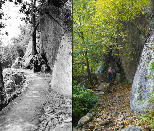
Marys Rock Trail: Fenton & Knox
A side by side comparison of a black and white historical photograph and a modern color photograph. Each photograph shows a trail on a ledge.
Marys Rock Trail in 1934 and 2016.
Permission must be secured from the individual copyright owners to reproduce any copyrighted materials contained within this website. Digital assets without any copyright restrictions are public domain.
Historical: NPS Archives/George C. Knox
2016: Cynthia Fenton
Public domain:Partial Granting Rights
Image
Shenandoah National Park, Code: SHEN
Shenandoah National Park, Virginia
Latitude: 38.3517684936523, Longitude: -78.5008163452148
Latitude: 38.3517684936523, Longitude: -78.5008163452148
08/15/1934 & 10/04/2016
07/20/2018
Public Can View
Thursday, September 6, 2018 12:15:36 PM
Thursday, September 6, 2018 12:15:36 PM
Marys Rock_2.jpg
Friday, July 20, 2018 10:10:16 PM
jpg
11.8 MB
Scenic