Select Item below to DOWNLOAD - Once item is selected, right click and choose 'save as'
f557530a-e162-4412-b6a0-feec3da9f951
Table1SummaryofAlternatives3.JPG
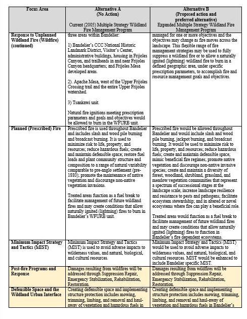
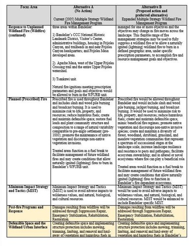
A table of text comparing two Alternatives (A and B) of Bandelier's Fire Management Plan Environmental Assessment
A table of text comparing two Alternatives (A and B) of Bandelier's Fire Management Plan Environmental Assessment
Pueblo and Four Winds Fire Ecology Program
National Park Service
Pueblo and Four Winds Fire Ecology Program
National Park Service
All Rights Reserved:Full Granting Rights:Pueblo and Four Winds Fire Ecology Program
National Park Service
Image
Bandelier National Monument, Code: BAND
Bandelier National Monument, New Mexico
Latitude: 35.8187789916992, Longitude: -106.357299804688
Latitude: 35.8187789916992, Longitude: -106.357299804688
01/01/2024
05/22/2025
Public Can View
Brinkman, Katherine Mckee
Organization: Pueblo and Four Winds Fire Ecology
Friday, May 23, 2025 8:28:32 PM
Friday, May 23, 2025 9:12:39 PM
Table1SummaryofAlternatives3.JPG
Thursday, May 22, 2025 11:30:12 AM
jpg
106.2 kB
Reports