Select Item below to DOWNLOAD - Once item is selected, right click and choose 'save as'
ee0e4eae-1fb0-4552-95b9-66ffb9a9e759
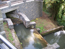
Singer Creek
Photograph of Singer Creek in the McLoughlin House unit.
Photograph of Singer Creek in the McLoughlin House unit, Fort Vancouver National Historic Site. Once flowing through the middle of the property, the creek has been re-routed to the south of the property and contained within a concrete channel.
Permission must be secured from the individual copyright owners to reproduce any copyrighted materials contained within this website. Digital assets without any copyright restrictions are public domain.
Photograph by John Graham (Colorado State
University).
Public domain:Full Granting Rights
Image
Fort Vancouver National Historic Site, Code: FOVA
Fort Vancouver National Historic Site
Latitude: 45.623851776123, Longitude: -122.662101745605
Latitude: 45.623851776123, Longitude: -122.662101745605
01/01/0001
Public Can View
Friday, July 2, 2021 3:31:02 PM
Friday, July 2, 2021 3:31:02 PM
18_FOVA_Signer_Creek.jpg
Monday, January 1, 0001 12:00:00 AM
jpg
180.0 kB
Scenic