Select Item below to DOWNLOAD - Once item is selected, right click and choose 'save as'
eb3f866423364d81a525071ee6aa35fb
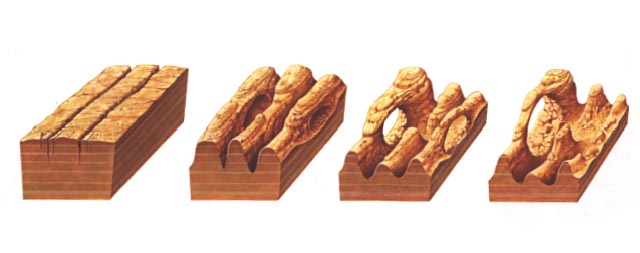
A diagram of the four (4) stages of arch formation in Entrada sandstone.
A diagram of the four (4) stages of arch formation in Entrada sandstone.
Abbr=WE
U.S. National Park Service
Art_Registration_No=WE-0148 ; Reflective Art
Government owns art and all reproduction rights.
Public domain
Image
Arches National Park, Code: ARCH
Arches National Park, Grand County, Utah
Latitude: 38.7224998474121, Longitude: -109.585998535156
Latitude: 38.7224998474121, Longitude: -109.585998535156
Image Management System : IMS 08668
20190904
01/01/1994 - 12/30/1994
Image_Size=19" x 8"; Count:2/2; Exhibit 11/Graphic # 11-9
P14
Public Can View
Organization: Harpers Ferry Center
Address: Harpers Ferry Center, 67 Mather Place, Harpers Ferry, WV, 25425, 304-535-5050
Address: Harpers Ferry Center, 67 Mather Place, Harpers Ferry, WV, 25425, 304-535-5050
Monday, October 7, 2019 2:40:04 PM
Monday, October 7, 2019 2:40:04 PM
08668.jpg
jpg
26.5 kB
Museum