Select Item below to DOWNLOAD - Once item is selected, right click and choose 'save as'
db3efa2c-800d-4069-a892-4122f57ef9c1
Claimant Testimony, page 2
Scanned image of form. See description for text.
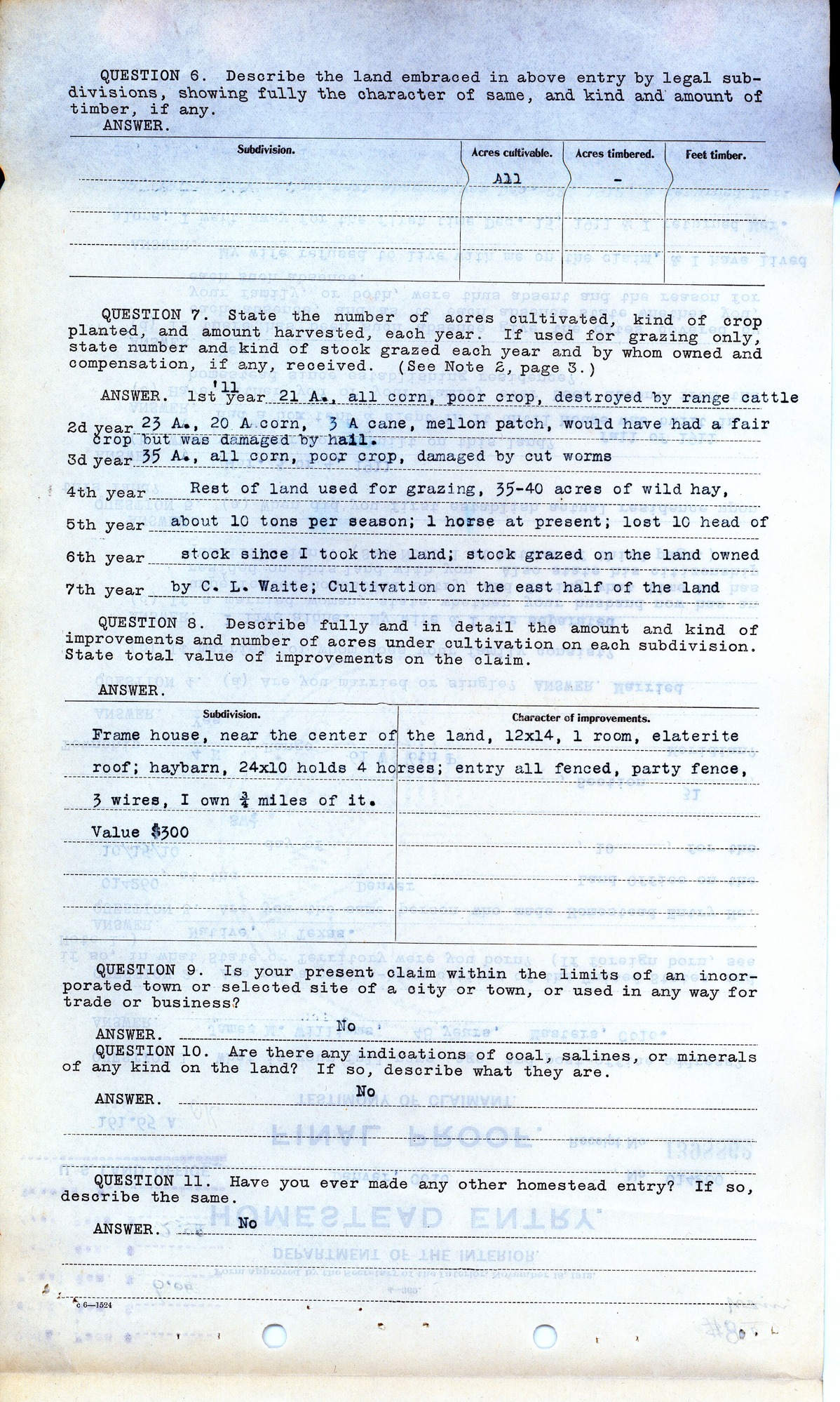
QUESTION 6. Describe the land embraced in above entry by legal sub-divisions, showing fully the character of same, and kind and amount of timber, if any.
ANSWER.
Subdivision. Acres cultivable. Acres timbered. Feet timber.
All -
QUESTION 7. State the number of acres cultivated, kind of crop planted, and amount harvested, each year. If used for grazing only, state number and kind of stock grazed each year and by whom owned and compensation, if any, received. (See Note 2, page 3.)
ANSWER. 1st year ’11 21 A. all corn, poor crop, destroyed by range cattle
2d year 23 A., 20 A corn, 3 A cane, mellon [sic] patch, would have had a fair crop but was damaged by hail.
3d year 35 A., all corn, poor crop, damaged by cut worms
4th year Rest of land used for grazing, 35-40 acres of wild hay,
5th year about 10 tons per season; 1 horse at present; lost 10 head of
6th year stock since I took the land; stock grazed on the land owned
7th year by C. L. Waite; Cultivation on the east half of the land
QUESTION 8. Describe fully and in detail the amount and kind of improvements and number of acres under cultivation on each subdivision. State total value of improvements on the claim.
ANSWER.
Subdivision. Character of improvements.
Frame house, near the center of the land, 12x14, 1 room, elaterite roof; haybarn, 24x10 holds 4 horses; entry all fenced, party fence, 3 wires, I own ¾ miles of it.
Value $300
QUESTION 9. Is your present claim within the limits of an incorporated town or selected site of a city or town, or used in any way for trade or business?
ANSWER. No
QUESTION 10. Are there any indications of coal, salines, or minerals of any kind on the land? If so, describe what they are.
ANSWER. No
QUESTION 11. Have you ever made any other homestead entry? If so, describe the same.
ANSWER. No
c 6—1524
Federal records are in the public domain
Public domain
Document
Homestead National Historical Park, Code: HOME
Weld County, Colorado
Latitude: 40.2879981994629, Longitude: -96.8339004516602
Latitude: 40.2879981994629, Longitude: -96.8339004516602
unknown
01/01/1914 - 12/30/1919
Land Entry Case Files: Homestead Final Certificates. Record Group 49: Records of the Bureau of Land Management. National Archives and Records Administration.
Public Can View
Organization: Homestead National Historical Park
Address: 8523 W State Hwy 4, Beatrice, NE 68310
Address: 8523 W State Hwy 4, Beatrice, NE 68310
Monday, October 18, 2021 1:48:49 PM
Thursday, July 17, 2025 9:04:22 PM
RG49.B14437.F.428771.5.tif
Monday, January 1, 0001 12:00:00 AM
tif
44.2 MB
Historic