Select Item below to DOWNLOAD - Once item is selected, right click and choose 'save as'
d64a22362c8d45bdae2b5cc1968f77cb
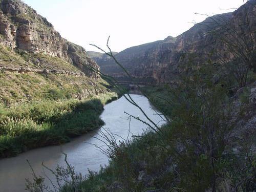
San Francisco. River Mile 709.66. September 2007.
Photo of the Rio Grande
Rio Grande vegetation monitoring, "San Francisco" photopoint at river mile 709.66, September 2007.
U.S. National Park Service
This camp is on the downstream side of the confluence of San Francisco Creek and the Rio Grande. The photo point is on the first limestone ledge across the creek from the camp and is marked with a cairn.
Permission must be secured from the individual copyright owners to reproduce any copyrighted materials contained within this website. Digital assets without any copyright restrictions are public domain.
NPS Photo
Public domain:This photo was taken by staff at Big Bend National Park and is part of the public domain.
Image
Big Bend National Park, Code: BIBE
Rio Grande Wild and Scenic River, Code: RIGR
Rio Grande Wild and Scenic River, Code: RIGR
Big Bend National Park, Brewster County, Texas
Latitude: 29.3278388977051, Longitude: -103.205894470215
Rio Grande Wild and Scenic River, Texas
Latitude: 29.3278388977051, Longitude: -103.205894470215
Rio Grande Wild and Scenic River, Texas
20070921
09/21/2007
Public Can View
Person: Resource Management
Organization: US National Park Service
Address: Big Bend National Park, P.O. Box 129, TX 79834-0129
Organization: US National Park Service
Address: Big Bend National Park, P.O. Box 129, TX 79834-0129
Monday, April 20, 2020 8:09:22 AM
Monday, April 20, 2020 8:09:22 AM
RIGR_RioGrande_RioGrandeVegMonitoring_709.66SanFranciscoL_20070921_7.TIF
tif
16.0 MB
Scenic
,
Monitoring