Select Item below to DOWNLOAD - Once item is selected, right click and choose 'save as'
d3b22cc8-68d0-499b-8e62-55430a4d63e1
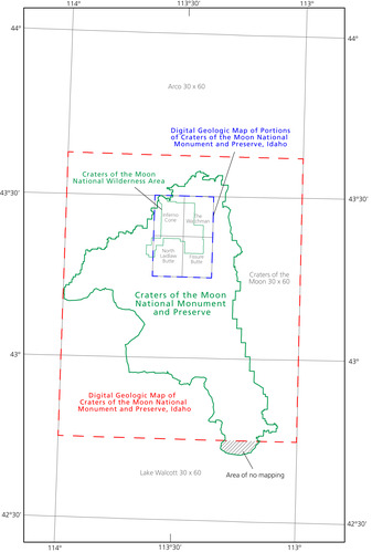
Index Map of GRI GIS Data for Craters of the Moon National Monument and Preserve
Index map of GRI GIS data for Craters of the Moon
The extent of Digital Geologic Map of Craters of the Moon National Monument and Preserve, Idaho (crmo_geology.mxd; scale 1:100,000) is outlined with a dashed red line and includes the Craters of the Moon 30’ × 60’ quadrangle and portions of the Arco and Lake Walcott 30’ × 60’ quadrangles. The extent of Digital Geologic Map of Portions of Craters of the Moon National Monument and Preserve, Idaho (cotm_geology.mxd; scale 1:24,000) is outlined with a dashed blue line and includes the Fissure Butte, Inferno Cone, North Laidlaw Butte, and The Watchman 7.5’ quadrangles. The gray hatch pattern on the southern edge of the preserve represents an area with no GRI digital geologic map coverage.
Permission must be secured from the individual copyright owners to reproduce any copyrighted materials contained within this website. Digital assets without any copyright restrictions are public domain.
Graphic by James Winter and
Stephanie O’Meara (Colorado State University).
Public domain:Full Granting Rights
Image
Craters of the Moon National Monument and Preserve, Code: CRMO
Craters of the Moon National Monument and Preserve, Idaho
Latitude: 43.0189094543457, Longitude: -113.626800537109
Latitude: 43.0189094543457, Longitude: -113.626800537109
07/23/2018
07/23/2018
Public Can View
Wednesday, July 21, 2021 3:17:05 PM
Wednesday, July 21, 2021 4:54:27 PM
Figure_56_crmo_index_map (1).jpg
Monday, July 23, 2018 8:06:01 PM
jpg
941.1 kB
Scenic