Select Item below to DOWNLOAD - Once item is selected, right click and choose 'save as'
d225d161-8e99-4eef-a974-940f84439d72
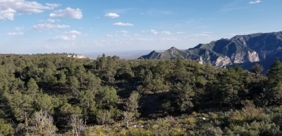
Guadalupe Ridge Trail Guadalupe Mountains National Park Carlsbad Caverns National Park
Looking into Texas from just north of the TX/NM border
The trail traverses the rocky peaks of the highest point in Texas, Guadalupe Peak (8,751’), to the challenging mountainous landscape of the New Mexico Chihuahuan Desert.
U.S. National Park Service
IN COPYRIGHT. This Item is protected by copyright and/or related rights. Copyright: Todd Shelley
Todd Shelley
Restrictions apply on use and/or reproduction:Copyrighted material
Image
National Trails System, Code: NTS
Guadalupe Mountains National Park, Code: GUMO
Guadalupe Mountains National Park, Code: GUMO
The trail is located between Guadalupe Peak, Guadalupe Mountains National Park and the boundary of Carlsbad Caverns National Park at White’s City, NM and passes through Bureau of Land Management and Lincoln National Forest property.
Guadalupe Mountains National Park, Texas
Latitude: 31.9068508148193, Longitude: -104.868301391602
Guadalupe Mountains National Park, Texas
Latitude: 31.9068508148193, Longitude: -104.868301391602
12/29/2021 12:00:00 AM
12/29/2021
Public Can View
Person: Todd Shelley
Organization: Guadalupe Mountains National Park
Address: Salt Flat, TX
Organization: Guadalupe Mountains National Park
Address: Salt Flat, TX
Friday, May 13, 2022 3:47:46 PM
Friday, May 13, 2022 3:47:46 PM
Guadalupe Ridge Trail 7.jpg
jpg
78.5 kB
Scenic