Select Item below to DOWNLOAD - Once item is selected, right click and choose 'save as'
CC17095F-155D-4519-3E04C9A67DA923C1
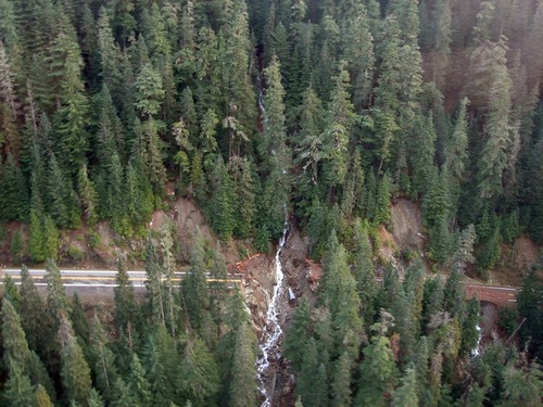
Major Washout on Highway 123
Aerial photo of a creek cutting through a forest and through a section of highway that is washed away.
Aerial surveys were first to spot a major washout at milepost 11 on Highway 123.
U.S. National Park Service
Permission must be secured from the individual copyright owners to reproduce any copyrighted materials contained within this website. Digital assets without any copyright restrictions are public domain.
Public domain:Full Granting Rights
Image
Mount Rainier National Park, Code: MORA
Mount Rainier National Park, Washington
Latitude: 46.865608215332, Longitude: -121.682601928711
Latitude: 46.865608215332, Longitude: -121.682601928711
7/16/2010 12:39:23 PM
Public Can View
Tuesday, January 2, 2018 11:07:47 AM
Friday, December 23, 2022 9:56:26 PM
CC172E87-155D-4519-3E155647486CD92D.jpg
SONY SONY, DSC-S40
10/250 sec at f / 2.8
5.1 mm
ISO 160
Wednesday, November 8, 2006 11:30:56 PM
jpg
413.7 kB
Scenic