Select Item below to DOWNLOAD - Once item is selected, right click and choose 'save as'
cacd9173-20e2-4e2f-9797-b4a07d63a755
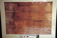
FOFR 1351 -- Map
Map from colonial town.
U.S. National Park Service
Permission must be secured from the individual copyright owners to reproduce any copyrighted materials contained within this website. Digital assets without any copyright restrictions are public domain.
Public domain
Image
Fort Frederica National Monument, Code: FOFR
Fort Frederica National Monument, Glynn County, Georgia
Latitude: 31.2236003875732, Longitude: -81.3898010253906
Latitude: 31.2236003875732, Longitude: -81.3898010253906
08/06/2001 - 08/07/2001
Public Can View
Thursday, December 21, 2006 1:49:28 AM
Thursday, August 10, 2017 9:04:34 AM
FOFR-b7d90f84e5b548629ce2569ca111f2c9.tif
Monday, January 1, 0001 12:00:00 AM
tif
398.5 kB
Museum
,
Map