Select Item below to DOWNLOAD - Once item is selected, right click and choose 'save as'
c9fb439d-135d-4a27-bee7-78d06186ba40
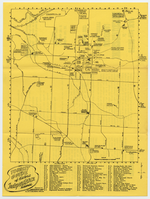
Tourist Brochure and Map of Independence, Missouri
A yellow brochure with a large map on one side.
A tourist brochure and map for Independence, Missouri. The map indicates a number of tourist destinations in Independence and surrounding areas. The brochure also gives a brief introduction to the city and it's history.
U.S. National Park Service
Contact the Harry S Truman National Historic Site for more copyright information and use.
Restrictions apply on use and/or reproduction
Image
Harry S. Truman National Historic Site, Code: HSTR
Harry S Truman National Historic Site, Independence, MO
Harry S. Truman National Historic Site, Jackson County, Missouri
Latitude: 38.9012985229492, Longitude: -94.5307006835938
Harry S. Truman National Historic Site, Jackson County, Missouri
Latitude: 38.9012985229492, Longitude: -94.5307006835938
ICMS (Interior Collection Managment System) : HSTR 6337
unknown
DPI 600
Cave Box 6
Public Can View
Organization: Harry S Truman National Historic Site
Address: 223 North Main, Independence, MO
Email: HSTR_Curator@nps.gov
Address: 223 North Main, Independence, MO
Email: HSTR_Curator@nps.gov
Friday, September 9, 2022 9:20:17 PM
Friday, September 9, 2022 9:20:17 PM
HSTR_6337_1.tif
tif
122.7 MB
Historic