Select Item below to DOWNLOAD - Once item is selected, right click and choose 'save as'
C96CFBCD-155D-4519-3E8B1FAFBFBED075
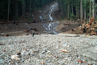
Bottom of the Landslide
A person stands on a wide gravel river bed at the base of a large landslide cut through a forest.
The bottom of the landslide is visible across the river from C loop.
U.S. National Park Service
Permission must be secured from the individual copyright owners to reproduce any copyrighted materials contained within this website. Digital assets without any copyright restrictions are public domain.
Public domain:Full Granting Rights
Image
Mount Rainier National Park, Code: MORA
Mount Rainier National Park, Washington
Latitude: 46.865608215332, Longitude: -121.682601928711
Latitude: 46.865608215332, Longitude: -121.682601928711
7/16/2010 12:41:17 PM
Public Can View
Tuesday, January 2, 2018 10:47:42 AM
Friday, February 10, 2023 12:00:27 AM
C96D5A00-155D-4519-3E2812F53AE285A5.jpg
Hewlett-Packard Hewlett-Packard, HP PhotoSmart 318
3038/1000000 sec at f / 28
6.79 mm
ISO 100
Thursday, November 9, 2006 6:52:10 PM
jpg
1.5 MB
Scenic