Select Item below to DOWNLOAD - Once item is selected, right click and choose 'save as'
c37388ac-53d9-4ec6-a6b8-be8d23e7eeef
April 25, Little Round Top Update
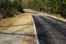
A dirt trail leads along a roadway with recently laid asphalt. Trees and boulders line the sides of the roadway.
A new stabilized aggregate trail leads from the summit to the new bus and oversize vehicle parking area along the north slope of Little Round Top. This trail connects to the accessible sidewalk system. Pavement work continues along Sykes Avenue.
Permission must be secured from the individual copyright owners to reproduce any copyrighted materials contained within this website. Digital assets without any copyright restrictions are public domain.
NPS Photo
Public domain:Full Granting Rights
Image
Gettysburg National Military Park, Code: GETT
Gettysburg National Military Park, Adams County, Pennsylvania
Latitude: 39.804500579834, Longitude: -77.2384033203125
Latitude: 39.804500579834, Longitude: -77.2384033203125
04/25/2024
04/25/2024
Public Can View
Friday, April 26, 2024 5:53:57 PM
Friday, April 26, 2024 6:05:27 PM
Jason_4-25-24__0012-1.jpg
Canon Canon, Canon EOS 60D 100, EF24-105mm f/4L IS II USM
1/800 sec at f / 5.6
24 mm
ISO 100
Thursday, April 25, 2024 3:04:25 PM
jpg
3.6 MB
Scenic