Select Item below to DOWNLOAD - Once item is selected, right click and choose 'save as'
c36cfb36-bb6d-446b-9df4-396ee7e66931
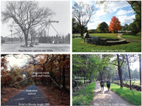
Restoration Areas
Historical and recent photographs of landscape restoration areas in Minute Man National Historical Park. Images includes 2 photo pairs. The top pair shows Paul revere capture site. One photo is from the 1950s with road, power lines, and modern buildings visible. Modern photo shows mature trees, grass buffer, and restored Battle Road Trail at the capture site. The bottom pair shows the road to Bloody Angle in 1990 and today. The 1990 photo shows a degraded asphalt surface to the road and vegetation obscuring the historic stone walls and fences. The modern photo show restored road bed, cleared field and battle-era forested area, as well as visible fences and stone walls.
Historical and recent photographs of landscape restoration areas in Minute Man National Historical Park.
Restoring disturbed lands to their battle-era appearance has involved removing buildings, planting fields, clearing
stone walls, removing asphalt, and restoring water courses.
Permission must be secured from the individual copyright owners to reproduce any copyrighted materials contained within this website. Digital assets without any copyright restrictions are public domain.
NPS photographs.
Public domain:Full Granting Rights
Image
Minute Man National Historical Park, Code: MIMA
Minute Man National Historical Park, Middlesex County, Massachusetts
Latitude: 42.4533996582031, Longitude: -71.2959976196289
Latitude: 42.4533996582031, Longitude: -71.2959976196289
01/01/0001
Public Can View
Monday, August 30, 2021 4:29:34 PM
Monday, August 30, 2021 5:28:19 PM
27_MIMA_thenandnow_0304-2016_tte-01.jpg
Monday, January 1, 0001 12:00:00 AM
jpg
2.4 MB
Scenic