Select Item below to DOWNLOAD - Once item is selected, right click and choose 'save as'
c30c647b-79dd-469a-aa20-96cb7fbaeaca
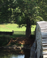
Streambank erosion control at Burnside Sycamore Tree
Streambank erosion control at Burnside Sycamore Tree, completed by YCC 2013
Streambank erosion control at Burnside Sycamore Tree
Permission must be secured from the individual copyright owners to reproduce any copyrighted materials contained within this website. Digital assets without any copyright restrictions are public domain.
Public domain
Image
Antietam National Battlefield, Code: ANTI
Burnside bridge ; Antietam NB, Antietam National Battlefield, Washington County, Maryland
Latitude: 39.470100402832, Longitude: -77.7380981445313
Latitude: 39.470100402832, Longitude: -77.7380981445313
08/20/2013
08/20/2013
Public Can View
Thursday, August 22, 2013 7:13:16 AM
Thursday, August 10, 2017 8:02:53 AM
ANTI-fb4faba2d9b4426c82efa82cde113891.jpg
Apple Apple, iPhone 4S
1/421 sec at f / 2.4
4.28 mm
ISO 50
Tuesday, August 20, 2013 6:12:44 PM
jpg
437.3 kB
Budget