Select Item below to DOWNLOAD - Once item is selected, right click and choose 'save as'
c0e49512-d9a1-4ea9-a105-2c26299c707b
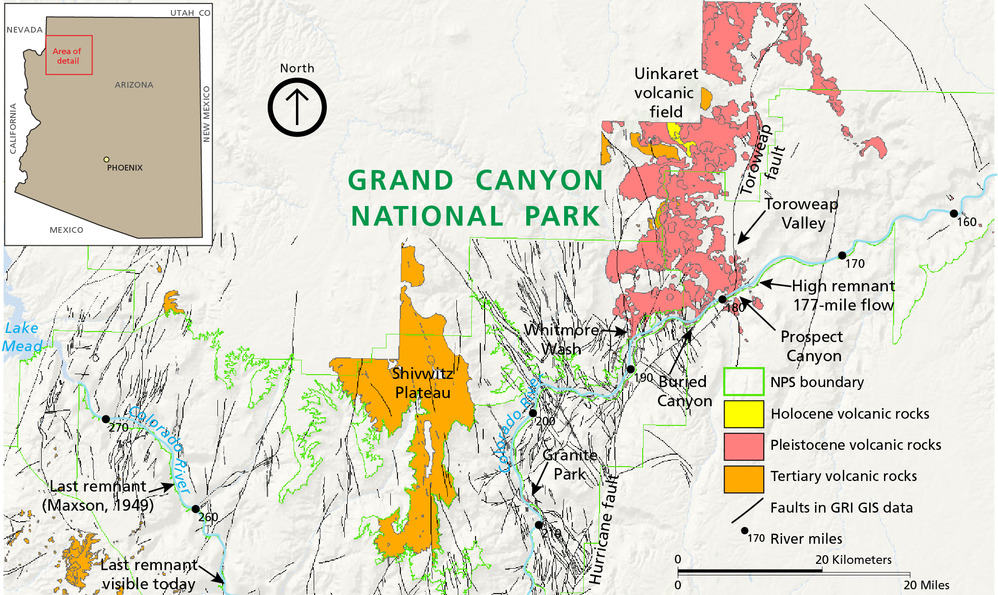
Simplified Geologic Map
Simplified geologic map showing the distribution of Tertiary and Quaternary basaltic volcanism. The volcanic deposits are primarily located north of the Colorado River and are delineated into 3 categories: Holocene volcanic rocks; Pleistocene volcanic rocks, and Tertiary volcanic rocks. Faults are also mapped.
Simplified geologic map showing the distribution of Tertiary and Quaternary basaltic volcanism.
Permission must be secured from the individual copyright owners to reproduce any copyrighted materials contained within this website. Digital assets without any copyright restrictions are public domain.
Map by Trista Thornberry-Ehrlich (Colorado State University) using GRI GIS data and information in
Billingsley (2000a), Billingsley and Wellmeyer (2003), and Billingsley et al. (2006) (Crow et al. 2015, figure
1).
Public domain:Full Granting Rights
Image
Grand Canyon National Park, Code: GRCA
Grand Canyon National Park, Arizona
Latitude: 36.3291397094727, Longitude: -112.790603637695
Latitude: 36.3291397094727, Longitude: -112.790603637695
01/01/0001
Public Can View
Friday, June 4, 2021 2:26:07 PM
Friday, June 4, 2021 2:26:07 PM
GRCA_32.jpg
Monday, January 1, 0001 12:00:00 AM
jpg
1.8 MB
Scenic