Select Item below to DOWNLOAD - Once item is selected, right click and choose 'save as'
bc35c811-b1dc-4d16-a6dd-e3a92fb5d07d
Tapeats Sandstone
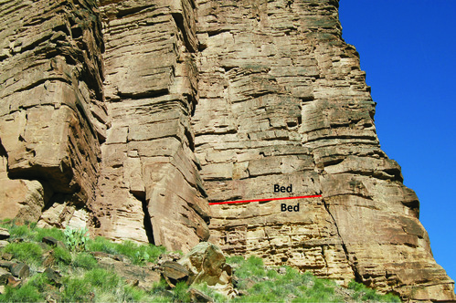
Photograph of tan cliffs composed of Tapeats Sandstone. Layers (beds) and fractures are visible.
Paleozoic strata form most cliffs and slopes in the park. In this photo, the Tapeats Sandstone (Ct) forms a topographic break above slopes of Sixtymile Formation (Zs). Strata are composed of a series of “beds” of various thickness. Two beds, and the contact between them, are highlighted in the diagram. Contacts between beds represent a change in depositional processes (e.g., erosion, fluctuating sea level, migrating
river or eolian systems).
Permission must be secured from the individual copyright owners to reproduce any copyrighted materials contained within this website. Digital assets without any copyright restrictions are public domain.
Modified from NPS photograph by Michael Quinn
Public domain:Full Granting Rights
Image
Grand Canyon National Park, Code: GRCA
Grand Canyon National Park, Arizona
Latitude: 36.3291397094727, Longitude: -112.790603637695
Latitude: 36.3291397094727, Longitude: -112.790603637695
01/01/0001
Public Can View
Friday, June 4, 2021 2:26:00 PM
Friday, June 4, 2021 2:26:00 PM
GRCA_21.jpg
Monday, January 1, 0001 12:00:00 AM
jpg
5.1 MB
Scenic